


Welcome to Orbit
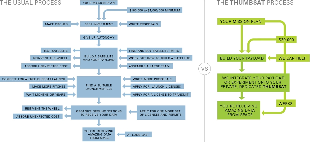
If you've ever dreamed of putting an experiment into space, ThumbSat is your one-stop solution. We provide the launch, the satellite platform, and handle the complex paperwork. Bring your experiment— we can help with that too. Get to orbit in a few months starting at ~$20,000, faster and more affordable than traditional alternatives.
Access Space Faster
Through our Launch Partnership with CAS Space, ThumbSat delivers the fastest path to orbit. Enjoy minimal overhead and flexible launch slots for any payload—from technology demos to education and beyond.
Our sister initiative, ThumbNet, opens access to space for students, universities, and citizen scientists worldwide—advancing science, technology, engineering, art, and mathematics.
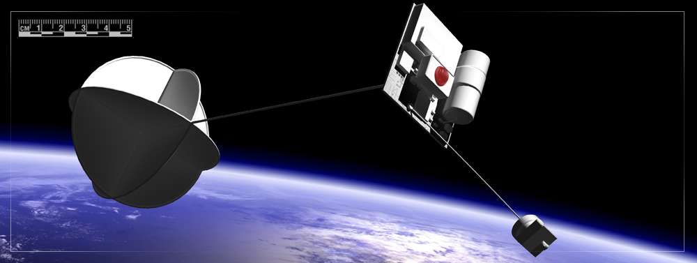
| Your experiment/payload | Various sizes and masses Typically: 48x48x(15-32)mm Mass: Up to 25g |
| Main computer | Microcontroller Built-in digital camera interface |
| Camera | High definition CMOS Active array of 2048(H) x 1536(V) pixels. Optional lenses and locations Uses: Microscope Macro camera Telescope Scanned configuration: "Selfie" option, on shape memory alloy boom |
| Memory | 128MB and 512MB Flash |
| Voltage converter | Increases low voltages to 5V Squeezes maximum energy out of the battery |
| GPS | Uses: Position-sensitive experiments Targeted download of data |
| Transmitter | 100mW Operating in 400MHz band |
| Battery | Lithium Thionyl Chloride Primary type Highest available energy density |
| Deployable tail/antenna | On shape memory alloy boom |
| Deployable vane | Uses:
Aerodynamic stability Drag enhancement Radar signature enhancement |
| Experiment Interface |
Variable, but typically: 3.6V unregulated power, 1.8Wh 5V regulated power 6x analogue in 1x analogue out (may be expanded using PWM channels) 2x USART interfaces 1x I2C interface 1x SPI interface 10x digital I/O |
Mission Control
Here you will be able to select a mission, view its actual or planned orbit, and find out information related to that mission, such as nature of the mission, and links to mission data.
 Past Missions (4)
| Launch ID | Launch Date | Orbit Data |
|---|---|---|
TS Q3 2025 LaunchDeployer ID: ThumbSat-1 Mission Name: TS01 Organization: Private Experiment Type: Demonstration Mission - Image Capturing | 19th Aug 2025 336 days elapsed | Altitude: 547.722km Speed: 7.594km/s Period: 95.4555minutes Semi major axis: 6918.72km Semi minor axis: 0km Eccentricity: 0.000604 Inclination: 97.4956° RAAN: 273.439 ° Arg of perigee: 182.144° Mean motion: 1.1422533333333E-16 rad/s Time in sunlight: 59 minutes Time in shade: 35 minutes Re-entry: 10th July 2026 |
TS Q3 2025 LaunchDeployer ID: ThumbSat-1 Mission Name: TS02 Organization: Private Experiment Type: Demonstration mission - LEO communication | 19th Aug 2025 336 days elapsed | Altitude: 547.722km Speed: 7.594km/s Period: 95.4555minutes Semi major axis: 6918.72km Semi minor axis: 0km Eccentricity: 0.000604 Inclination: 97.4956° RAAN: 273.439 ° Arg of perigee: 182.144° Mean motion: 1.1422533333333E-16 rad/s Time in sunlight: 59 minutes Time in shade: 35 minutes Re-entry: 10th July 2026 |
RL Q4 2017 Launch 2Deployer ID: TS-B Mission Name: Star 1 Organization: Private Experiment Type: Multiple small payloads to Earth orbit. | 12th Dec 2017 3143 days elapsed | Altitude: 500km Speed: 7.6km/s Period: 95minutes Semi major axis: 6880km Semi minor axis: 6880km Eccentricity: 0 Inclination: 98° RAAN: 0 ° Arg of perigee: 0° Mean motion: 1.1422533333333E-16 rad/s Time in sunlight: 59 minutes Time in shade: 36 minutes Re-entry: 2nd November 2018 |
RL Q1 2017 Launch 1Deployer ID: TS-A Mission Name: LomStar 1 Organization: Private Experiment Type: A fantastic education and outreach project. | 15th Sep 2017 3231 days elapsed | Altitude: 500km Speed: 7.6km/s Period: 95minutes Semi major axis: 6880km Semi minor axis: 6880km Eccentricity: 0 Inclination: 98° RAAN: 0 ° Arg of perigee: 0° Mean motion: 1.1422533333333E-16 rad/s Time in sunlight: 59 minutes Time in shade: 36 minutes Re-entry: 6th August 2018 |
Ground Stations (249)
Argentina
Engineering ClubAustralia
Mcarthur Adventist CollegeCentral Coast Rudolf Steiner SchoolWiletton Senior High SchoolKormilda CollegeCentralian Senior CollegeDill International SchoolPrivate IndividualGeorgetown State SchoolMLC SchoolParklands High SchoolSt Luke's CollegeLooma EaglesInvestigator College Year 5VictorCharleville State High SchoolOakey State High SchoolGympie SHSClarendon Primary SchoolVictory CollegeCairns State High SchoolDundula State SchoolNew Town High SchoolJohn Willcock WarriorsMarian Catholic CollegeBarbados
Private IndividualBelize
Belize High SchoolBolivia
SCIS HeikenCanada
Boy Scout TroopLeoncornus LTD.NWCC HazeltonLightages GuelphAmalgamated AcademyMrD's Grade 5Menihek HighschoolUpRoute Space ProgramLakecrestBert Church High SchoolChile
Thumbs Up, Chile!Christmas Island
Christmas Island High SchoolCosta Rica
Costa Rica International AcademyCroatia
AISZ Design TechDominican Republic
Private IndividualEl Salvador
Academia Britnica CuscatlecaFalkland Islands
Falkland Islands Community SchoolIndia
Fountainhead School SuratEastern Public SchoolCENSymbiosis Institute of TechnologySudip KarSPACEPORT INDIAIsrael
Private individualKenya
ISKKosrae
Private IndividualLithuania
LietuvaMadagascar
Chrysalis SchoolMalaysia
BSKL Mission ControlMexico
Colegio YavneMongolia
ISU MongoliaNamibia
Karabib Private SchoolNetherlands Antilles
International School of CuracaoPakistan
Private IndividualPeru
Markham CollegePhilippines
Philippine Science High School - Ilocos Region CampusPhilippine Science High School Caraga Region CampusPhilippine Science High School Southern Mindanao CampusPhilippine Science High School Soccksargen Region CampusPoland
atomusPortugal
Eduardo ArraiaSao Tome and Principe
Instituto Diocesano de FormaoSeychelles
International School SeychellesSumatra
Medan Independent SchoolTaiwan
AMSAT-TWTanzania
IST Secondary Science DepartmentTrinidad And Tobago
The International School of the Port of SpainTurkey
ACIUnited Kingdom
Private IndividualPrivate IndividualPrivate IndividualPrivate IndividualParallel 58Private IndividualCharlies AngelsRG40Barry WhiteheadUnited States
Gateway SchoolUruguay
Uruguayan American SchoolVenezuela
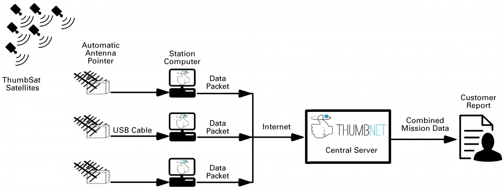
Private IndividualHow to collect data from fast-moving satellites that are only within range of a ground radio receiver for minutes? Create a global network of internet-linked "grounds stations" - ThumbNet!
The most active volunteers will receive even more - the free tracking station described below. All you need is enthusiasm, a small space to mount an antenna/tracker where it can see the sky, a power source and internet access. No special knowledge, equipment or experience is needed.
It’s a great way to learn about Science, Technology, Engineering and Mathematics, and to be involved in a global project! Begin the volunteer process by filling out the ThumbNet Registration Form . In the meantime, if you want to discover more, read on...
The details...
The ThumbNet project has already begun changing the lives of students, educators and citizen scientists around the planet and is having a positive impact on the communities where it is active!
ThumbNet is an educational project encouraging students and average citizens around the globe to experiment with space science and engineering, while building a global network of monitoring stations for satellites in orbit, and we'd love for you to participate!
The concept is simple. Satellites in orbit are transmitting their data back to the ground, but due to their motion in orbit, a single station can only receive signals from a particular satellite for roughly 6 to 10 minutes. And that's just not enough time to get all of the mission data!
But, by locating antennas around the world and linking them together through the power of the internet, we can create a global network to remain in constant communication with the satellite. And that's where you can help.
Due to the nature of the system and the simplicity of the components, there are thousands of locations around the globe that would be a perfect place to set up one these experiments.
Looking at the map above or expanding the Ground Station list proves that:
- No large infrastructure or high voltage power is required
- There is no special permitting needed
- No radio regulations are being violated
- No buildings or towers need to be constructed
For the first time ever, communities and high schools in tiny nations such as Christmas Island, or Sao Tome & Principe have the same opportunity to educate their students using services that previously were only available to large, well connected universities.
We are looking for anyone (young or old, educated or uneducated, individuals or groups) who is interested in learning more about radio, space, science and engineering. All that is needed is a computer with an internet connection and a few square meters of space on the roof of a building to mount the tracking station.
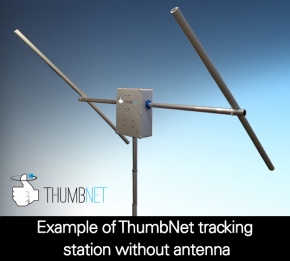
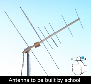
As the experimenter, you and your group will build a simple radio antenna (that looks like a TV aerial) that can be constructed in a morning with readily available materials.
The antenna will be combined with an easy to assemble kit, that we provide, that will allow you to set up your own ground station for tracking satellites in space and downloading their signals while operating in manual or fully automatic mode.
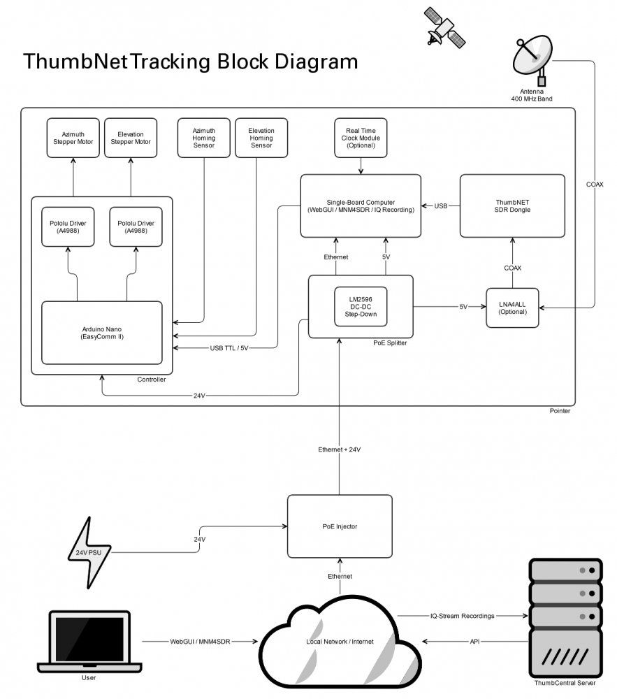
The tracker is capable of rotating 360 degrees or pointing 0 to 180 degrees in elevation. Perfect, for following any satellite that might be passing overhead.
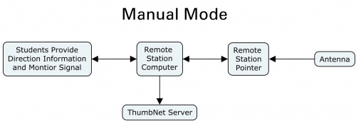
In Manual Mode, the student uses the station's computer to send signals to the antenna tracker, telling it which direction to point to. Then, he or she can manually adjust the position of the antenna to follow the satellite and using the software provided, download and listen to the signals being broadcast. In Manual Mode, the tracking station's computer sends data to the ThumbNet server, but the server does not send commands to the remote station.
In Automatic Mode, the tracking station receives commands from the ThumbNet server and also sends data back to the server for merging with other station data. The student can monitor the data being downloaded from the satellite, but cannot point the antenna to another direction without switching to Manual Mode. (Note - The station cannot be put into Manual Mode, if there is a ThumbSat satellite that is active and visible to the tracking station.)
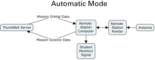
The default mode when powering up the station is Automatic Mode. If the station is left idle in Manual Mode for 30 minutes or longer, the station will switch itself to Automatic Mode and begin accepting commands from the ThumbNet server.
The internal workings and basic block diagram of the tracking station are shown in the images below. While it may LOOK complicated, we have spent a lot of time making sure that it is easy for anyone to assemble. Most of the design is simple "Plug and Play" components and only basic hand tools like a drill and screwdriver are required. Building the station is an excellent way to engage students immediately and provides them with a sense of ownership of the station and a better understanding of how and why it works.
Of course, we provide all of the software and procedures needed to operate the station and communicate effectively with the rest of the network.
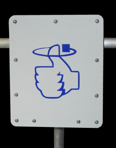
Tracking Station Front Cover
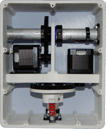
Mechanical Install of the ThumbPointer Hardware.
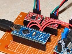
Prototype Board of Arduino Nano and Stepper Motor Drivers
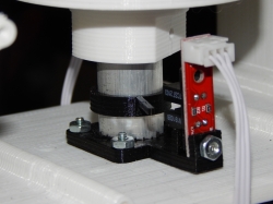
View of the AZ Homing Sensor and Trigger
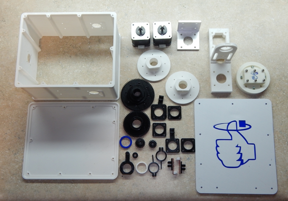
Non-Electronic Pieces Ready For Assembly.
The 3D printable files for the base tracking station are now available in the Virtual Classroom.


 Web Design